
Contact us
WE’D LOVE TO HEAR FROM YOU
Planning a stay at Senyati, have a question about accommodation or looking to explore the Chobe region?
Get in touch with our team. We’re happy to help you plan your visit.


Directions to Senyati Safari Camp
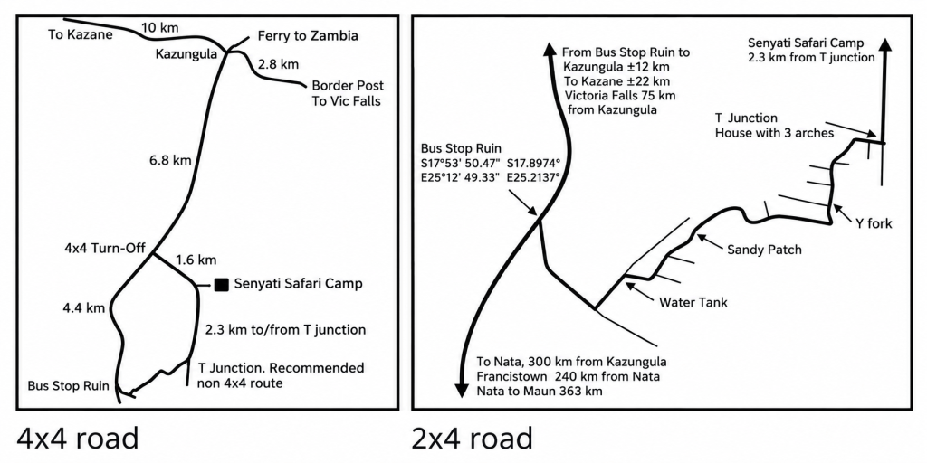
Important Road Information
If you are driving a 4×4, you may use the 1.6 km sandy road to Senyati, marked as the “4×4 Turn-Off” on the Area Map.
If your vehicle is not a 4×4, we recommend taking the alternative 2×4 route.
Do not attempt the 4×4 route with a non-4×4 vehicle, as you are likely to get stuck.
From Nata to Senyati
- Approximately 84 km after Pandamatenga, you will see the Lesoma turn-off sign.
- Turn right at the old Bus Stop Ruin, which will be on your left, onto the dirt road.
- After approximately 550 metres, take the first road on your left.
- Continue until you see a large water tank on your right.
- At the water tank, veer right and follow the winding road.
- Continue following the main winding road, keeping left at the bends.
- At the Y-fork, take the right-hand road.
- Continue until you reach a house with three arches at the front, marking a T-junction. Turn left.
- Drive for 2.3 km. The Senyati Reception sign will be on your right.
From Kasane / Kazungula to Senyati
- Approximately 12 km from Kazungula, you will see the Lesoma turn-off sign.
- Turn left onto the dirt road, directly opposite the Bus Stop Ruin.
- After approximately 550 metres, take the first road on your left.
- Continue until you see a large water tank on your right.
- At the water tank, veer right and follow the winding road.
- Continue following the main winding road, keeping left at the bends.
- At the Y-fork, take the right-hand road.
- Continue until you reach a house with three arches at the front, marking a T-junction. Turn left.
- Drive for 2.3 km. The Senyati Reception sign will be on your right.

